The Challenge: Traditional Soil Testing Doesn’t Scale.
Physical sampling campaigns are slow, labor-intensive, and cost-prohibitive. To manage agricultural landscapes sustainably, you need continuous, high-resolution data—not static, outdated reports.
lightbulb The Solution: SoilSatAI
SoilSatAI bridges the gap between the lab and the field. By combining physical ground-truth measurements with advanced machine learning and satellite imagery, we deliver high-fidelity soil property estimates across massive landscapes—without the intensive sampling overhead.
How accurate are SpectrAI’s soil carbon predictions?
Our machine learning models are designed to provide reliable and scalable estimates of soil organic carbon (SOC) by combining georeferenced field measurements with multi-source satellite and geospatial data. Model performance is evaluated using independent validation datasets to assess predictive accuracy, robustness, and spatial consistency across agricultural landscapes.
Rather than relying exclusively on sparse physical sampling, our approach integrates continuous earth observation data with AI-driven calibration workflows to generate statistically validated SOC predictions at scale. Performance metrics such as R², RMSE, MAE, and regression slope are used to quantify model quality and evaluate the agreement between predicted and observed SOC values.
The validation example presented here features results from an agricultural field located in Ontario, Canada, where predicted SOC values derived from satellite and geospatial data are compared against observed field measurements. The fitted regression demonstrates a strong correlation between AI-predicted and ground-truth SOC observations, while also illustrating the natural variability typically encountered in environmental and agronomic datasets.
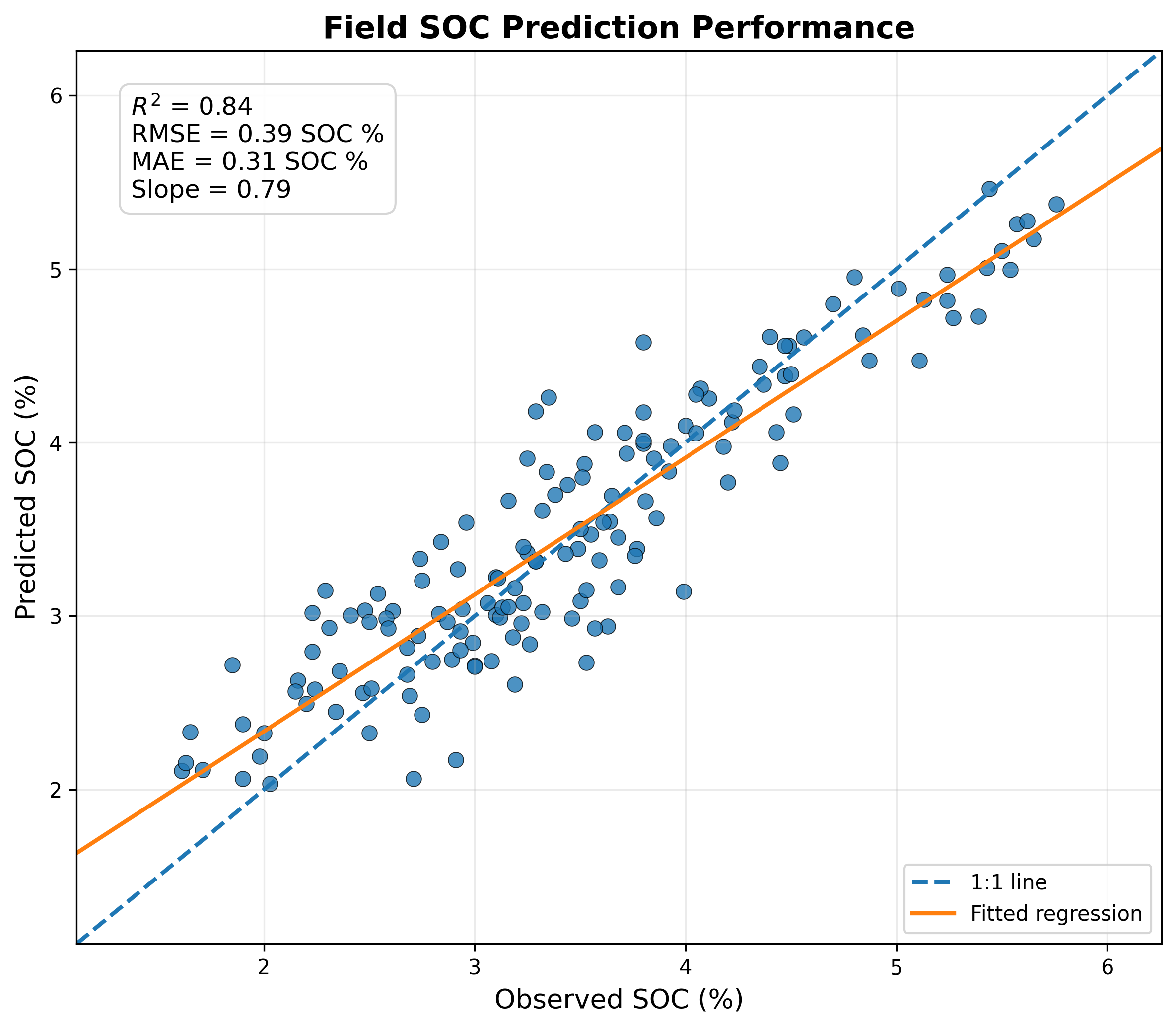
Figure: Validation example from Ontario, Canada, comparing observed soil organic carbon measurements with AI-predicted SOC.
In practice, model performance can vary depending on factors such as climate conditions, soil composition, crop systems, sampling density, and the availability of regional calibration datasets. For this reason, uncertainty quantification and independent validation procedures remain central components of our modeling framework. As additional soil measurements and earth observation datasets become available, the models can be progressively refined to improve predictive stability, regional adaptability, and large-scale transferability.
Core Pillars of Our Technology
Built to scale, adapt, and provide absolute scientific transparency.
Grounded in Field Data, Elevated by AI
Every model is calibrated using real-world field measurements. We don’t guess; we learn. Our algorithms map relationships between observed soil properties and spatial signals, blending physical truth with digital scale.
Multi-Dimensional Spatial Intelligence
We look beyond the surface by analyzing complex environmental data:
- check_circle Multispectral Satellite Imagery
- check_circle Terrain & Elevation Data
- check_circle Climate Variables
Scalability That Adapts
Agricultural soils change drastically. SoilSatAI’s spatial machine learning frameworks adapt to highly variable environments. Workflows evolve dynamically as new data flows in for continuous spatial assessment.
Scientifically Rigorous & Audit-Ready
Built for enterprise compliance and global methodologies:
- check_circle Reproducibility
- check_circle Spatial Traceability
- check_circle Uncertainty-Aware Analysis
At the Intersection of Science & Scale
SoilSatAI isn’t just a software tool; it’s a category-defining platform born from the convergence of four critical disciplines.
Remote Sensing
Next-gen satellite data ingestion
Artificial Intelligence
Predictive ML models
Soil Science
Deep agronomic expertise
Geospatial Analytics
Field-scale mapping globally
Ready to transform your soil data into actionable asset intelligence?
Whether you are managing carbon credit programs, optimizing corporate supply chains, or driving precision agriculture at scale, SoilSatAI delivers the insights you need.